Skip to content
PolGeoNow Control Maps

Professional Conflict Mapping Service

  • About
  • Map Series
    • Israel/Palestine
    • Somalia
    • Sudan
    • Syria
    • Ukraine
    • Yemen
    • Other Conflicts
  • By Actor
    • “Islamic State” & Affiliates
    • Al Qaeda Affiliates
    • Arab States
    • African Governments
    • US Military
    • Russian Presence
    • Turkish Involvement
    • Breakaway States
  • Log In

Syrian Civil War Map & Timeline: “Islamic State” Territory in Pieces – December 2017 (Subscription)

December 14, 2017

By our estimates, IS territory in Syria is now divided into seven separate pieces: four in the eastern desert near Iraq, where the campaign against the group is focused, and three scattered across the country’s west.

Syrian Civil War Map & Timeline: “Islamic State” Territory in Pieces – December 2017 (Subscription) Full Article »

Iraq Control Map & Timeline: “Islamic State” Loses Last Towns – November 2017 (Subscription)

November 30, 2017

In the aftermath of Kurdistan’s defiant independence referendum, its forces have been pushed back to their pre-2014 territory by an Iraqi government offensive. Meanwhile, IS has lost the last two towns it controlled in the country.

Iraq Control Map & Timeline: “Islamic State” Loses Last Towns – November 2017 (Subscription) Full Article »

Philippines: No More “Islamic State” Control in Marawi

November 21, 2017

The siege of Marawi City finally came to an end on October 23, exactly five months after it started, with the capture of the last rebel-held building by the Armed Forces of the Philippines.

Philippines: No More “Islamic State” Control in Marawi Full Article »

Syrian Civil War Map & Timeline: “Islamic State” Exits Last Major City – November 2017 (Subscription)

November 15, 2017

Early this month, the Syrian government – with support from Russia – completed its capture of Deir ez-Zor, the last major urban center controlled by IS anywhere in the world.

Syrian Civil War Map & Timeline: “Islamic State” Exits Last Major City – November 2017 (Subscription) Full Article »

Syrian Civil War Map & Timeline: SDF Captures Raqqah – October 2017 (Subscription)

October 27, 2017

The Kurdish-led Syrian Democratic Forces have completed their control of Raqqah, once capital city of the so-called “Islamic State”, and taken the country’s largest oil field, while government forces have captured the temporary IS headquarters of Mayadin.

Syrian Civil War Map & Timeline: SDF Captures Raqqah – October 2017 (Subscription) Full Article »

Iraq Control Map & Timeline: Government Takes Kirkuk from Kurdistan – October 2017

October 17, 2017

The Iraqi government has retaken the disputed city of Kirkuk from Kurdish forces in retaliation for the controversial Kurdistan independence referendum, while also driving the so-called “Islamic State” out of two northern enclaves.

Iraq Control Map & Timeline: Government Takes Kirkuk from Kurdistan – October 2017 Full Article »

Syrian Civil War Map & Timeline: Siege of Deir ez-Zor Broken – September 2017 (Subscription)

September 29, 2017

The so-called “Islamic State” has nearly been confined to Syria’s far east, and no longer surrounds military forces who had held out for years in a government-controlled enclave of Deir ez-Zor city.

Syrian Civil War Map & Timeline: Siege of Deir ez-Zor Broken – September 2017 (Subscription) Full Article »

Libya Control Map & Timeline – September 2017 (Subscription)

September 22, 2017

The eastern Libyan National Army (LNA) has completed its years-long campaign to secure control of Benghazi city from religious hardline fighters, while the western authorities face off with a third government faction.

Libya Control Map & Timeline – September 2017 (Subscription) Full Article »

Syrian Civil War Map & Timeline – August 2017 (Subscription)

August 30, 2017

As the Kurdish-led Syrian Democratic Forces continue the battle for “Islamic State” capital Raqqah, IS has lost wide swaths of central and western Syria to government offensives.

Syrian Civil War Map & Timeline – August 2017 (Subscription) Full Article »

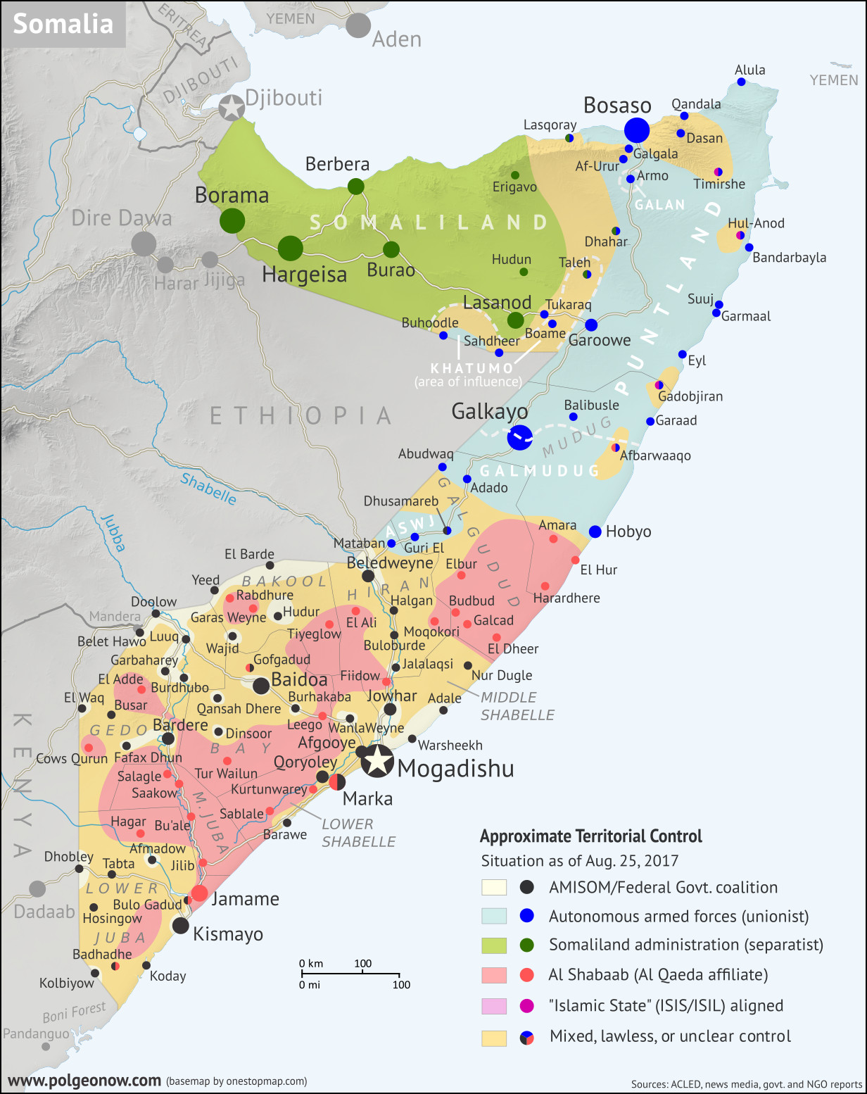
Somalia Control Map & Timeline – August 2017

August 26, 2017

PolGeoNow presents our all-new map of territorial control in Somalia, painstakingly researched and professionally designed to be the best available anywhere online.

Somalia Control Map & Timeline – August 2017 Full Article »

Posts navigation
← Previous Page 1 … 16 17 18 … 31 Next Page →
  • About Us
  • Contact
  • Using Our Maps
  • Privacy Policy
  • www.polgeonow.com
This site has no cookie consent popup banner. That's because we don't currently use any tracking or analytics cookies (see our privacy policy for more details).

Having any difficulties or technical problems using this site? If you have time to email us about it, we'll take it very seriously. Our preferred browser is Mozilla Firefox.

Copyright © 2011-2026 Political Geography Now

Start typing and press enter to search