Somalia Control Map & Timeline – August 2017
PolGeoNow presents our all-new map of territorial control in Somalia, painstakingly researched and professionally designed to be the best available anywhere online.
Professional Conflict Mapping Service
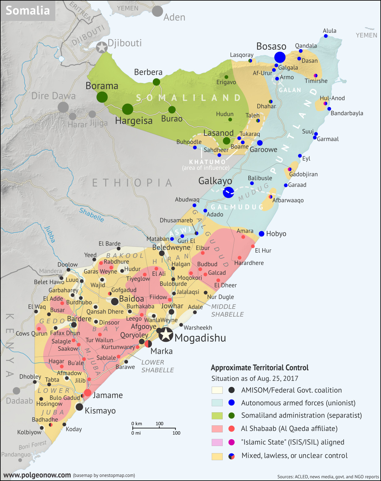
PolGeoNow presents our all-new map of territorial control in Somalia, painstakingly researched and professionally designed to be the best available anywhere online.

Fighting has continued with only small changes of territorial control along the front lines between Yemen’s two rival governments, while Al Qaeda has lost a few of its last controlled towns to a US-backed government campaign.
Yemen Control Map & Report: August 2017 (Subscription) Full Article »

Iraqi government forces and allies have completed their recapture of Mosul, Iraq’s third biggest city and the largest urban center ever controlled by the so-called “Islamic State”.
Iraq Control Map & Timeline: “Islamic State” Loses Mosul – July 2017 (Subscription) Full Article »

Kurdish-led force have fully surrounded Raqqah, while the Syrian government has gained ground against both rebels and IS to once again become the war’s largest player by territorial control.

The IS capital of Raqqah has been breached by the Kurdish-led Syrian Democratic Forces, while government-aligned soldiers continue to gain ground as well, reaching the Iraqi border for the first time since 2015.
Syrian Civil War Map & Timeline: Kurds Enter “Islamic State” Capital – June 2017 Full Article »

As government forces have battled their way into Mosul, the largest city held by the so-called “Islamic State”, pro-government militias have pushed their way west all the way to the Syrian border.
Iraq Control Map & Timeline – June 2017 (Subscription) Full Article »

The eastern government’s Libyan National Army (LNA) has expanded its control over the country’s interior, while the so-called “Islamic State” has reportedly re-emerged in rural areas. Map now shows autonomous Tuareg and Toubou forces in separate colors.
Libya Control Map & Timeline – June 2017 (Subscription) Full Article »

Rebels aligned to the so-called “Islamic State” have overrun parts of Marawi, the largest city in the southern Philippines’ Muslim-governed autonomous zone.

As the so-called “Islamic States” continues to lose territory from multiple sides, rebel-government frontlines are hardening into designated “de-escalation zones” (now labeled on map).
Recent months have seen small territorial gains for the internationally-recognized government of President Hadi, mostly along the Red Sea coast and the northern border with Saudi Arabia.
Yemen Control Map & Report: May 2017 (Subscription) Full Article »