Somalia Control Map & Timeline – August 2017
PolGeoNow presents our all-new map of territorial control in Somalia, painstakingly researched and professionally designed to be the best available anywhere online.
Professional Conflict Mapping Service
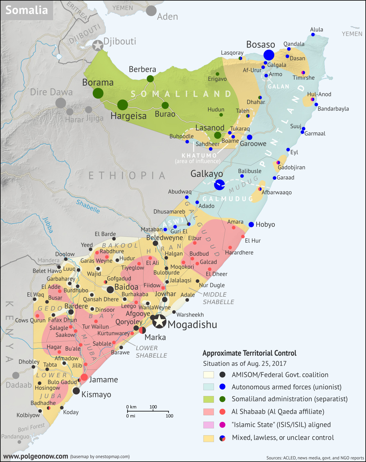
PolGeoNow presents our all-new map of territorial control in Somalia, painstakingly researched and professionally designed to be the best available anywhere online.

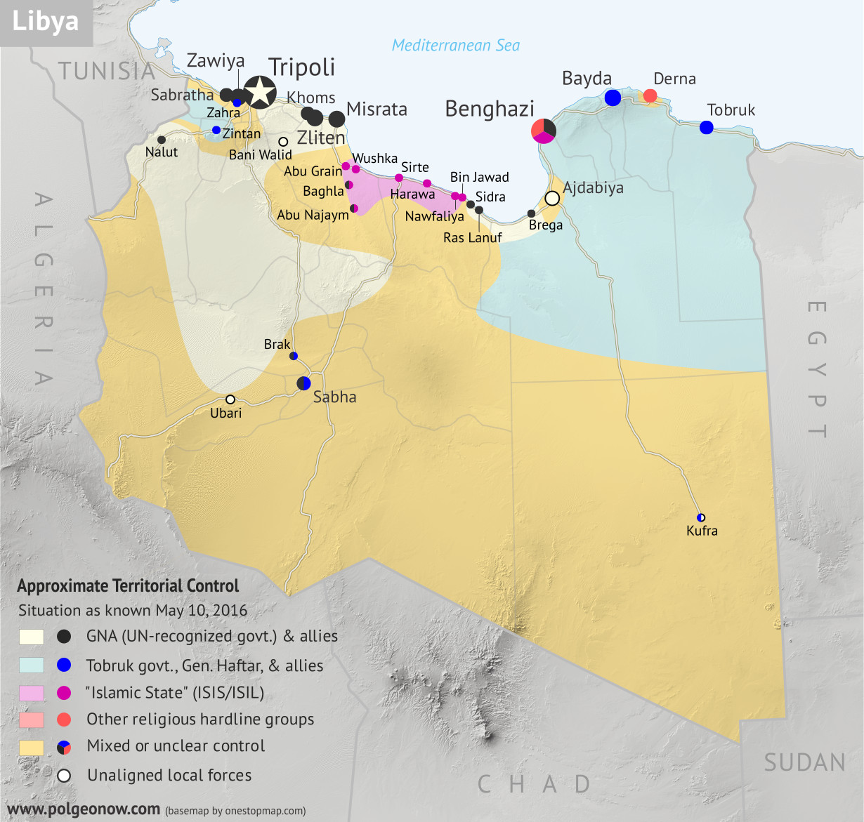
The eastern government’s Libyan National Army (LNA) has expanded its control over the country’s interior, while the so-called “Islamic State” has reportedly re-emerged in rural areas. Map now shows autonomous Tuareg and Toubou forces in separate colors.
Libya Control Map & Timeline – June 2017 (Subscription) Full Article »

Libya’s two rival governments have increasingly faced off directly in the southern desert, even as eastern forces continue their campaign against religious hardliners. Meanwhile, a new “neutral” military force has emerged in the west.
Libya Control Map & Timeline – April 2017 (Subscription) Full Article »

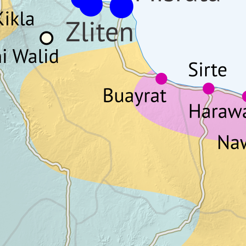
Forces aligned with the UN-backed Government of National Accord have driven the so-called “Islamic State” out of the town of Sirte, its last stronghold in Libya.

The so-called “Islamic State” has been nearly driven out of its Libyan territory, with its central stronghold shrunken to just a part of Sirte town.
The Fall of Libya’s “Islamic State”: Sept. 2016 Control Map & Timeline (Subscription) Full Article »
From March to May, the structure of Libya’s divided control and rival governments underwent a massive realignment, with international recognition essentially switching from one side of the country to the other, and some key fighting forces switching sides as well.
Libya’s Political Realignment: May 2016 Control Map & Timeline Full Article »
As Libya attempts to implement a new political unity deal, this edition of the map features updated approximations of the control lines and has added major roads.
Libya Control Map & Report: March 2016 (Subscription) Full Article »
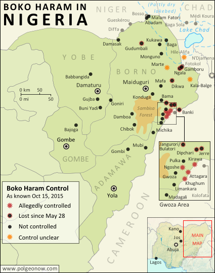
“Boko Haram” insurgents, now calling themselves the West Africa Province of the so-called “Islamic State”, still hold onto control of a few remote locations in Nigeria’s far northeast despite government advances.
Map of Boko Haram/”Islamic State” Control in Nigeria: October 2015 Full Article »

This first edition of PolGeoNow’s new Libya control map series shows a country split between two rival governments and the so-called “Islamic State”, while the accompanying report summarizes events since the fall of Gaddafi in 2011.

Two years after Mali was tentatively reunited by a French-led military intervention, skirmishes between government and separatist forces have continued, and rebels again control parts of the country’s north.