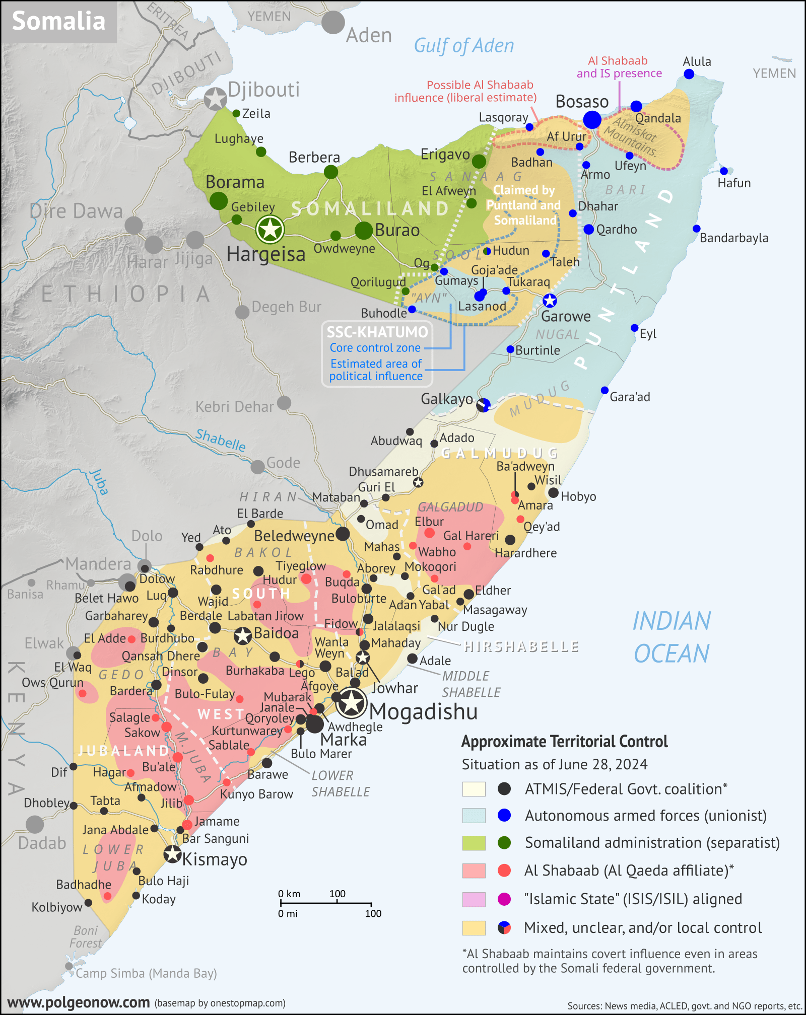
This is preliminary edition of our Somalia map has now been superseded by a final version of the map. We are leaving it online to avoid breaking any links that have been made referencing it, but strongly recommend that all readers disregard it in favor of our final map and in-depth report for this date:
June 2024 Somalia Control Map & Timeline: Height of ISIS Control, Al Shabaab Stalemate
Obsolete version of the map follows:
While the final version of our 2024 Somalia Control Map and report is unfortunately still not ready, subscribers can find here a “preliminary edition” of the map that we previously shared with customers who had asked about our progress. This map shows our tentative assessment of the situation as of June 28, 2024 (for more details, see below).
The final version of the map will be updated to approximately the current date at the time it is published, and will be prominently linked to here.
(To see other maps in this series, view all Somalia updates.)

How does the “preliminary edition” differ from the final version?
This preliminary edition of the map is designed to be almost entirely as accurate as the final edition will be, if only a bit less precise – the (limited) areas for which research and fact-checking are still ongoing have been marked as “mixed/unclear”. The final version is expected to differ from this preliminary edition only in the following regards:
- A small part of the area now marked as “mixed/unclear” will hopefully be clarified and marked as under control of one or another of the relevant parties, if relevant evidence is found
- Assessments will be updated to roughly the current date when the final edition is published, resulting in changes to the map for any relevant events that will have occurred since June 28
- Cartographic adjustments: For example, we will likely choose to add some relevant small towns or villages to the final edition that aren’t now shown, or we may make other modest improvements to how the situation is presented.
- Although we initially hoped that we would not need to retrospectively extend the area of “mixed/unclear” into any of the areas marked as controlled by any given party on this preliminary edition, it now appears that the final edition will contain a few such changes, though very minor.
The final edition will of course also benefit from a report providing a timeline of territorially-relevant events, including links to the sources we’ve used.
We’re also working on a new set of procedures to streamline the process of making updated maps like this one, and expect to be able to produce updates a bit more frequently in the future. In the meantime, we are deeply thankful for the impressive patience that many of you have shown while waiting for the long-overdue final version.
This preliminary map edition was originally shared directly with subscribers who requested it starting on July 30, 2024. It was published in the subscriber portal on October 16, 2024, but backdated to July 30 in the system.
